Fresno County’s Deadliest State Routes
Fresno County’s Deadliest State Routes
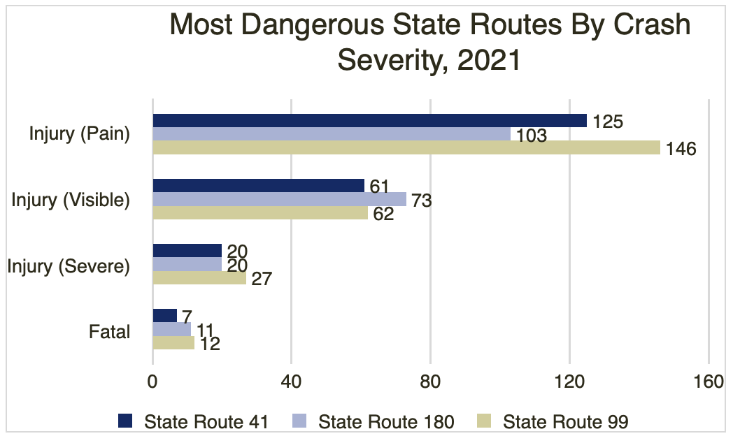
The city of Fresno is known for its affordability, agriculture, red wines, and uncharacteristically gloomy weather (for California, at least!). However, Fresno County is also home to some of the California’s most dangerous state routes to drive on. Particularly during rush hours, highway traffic can quickly get congested, claustrophobic, and sometimes even dangerous. In fact, State Route 99, which passes through Fresno County, was deemed the most dangerous highway in the entire United States in 2019. Is driving on Highway 99 still risky in 2022? Let’s look at the data.Fresno County’s Most Dangerous State Routes: Quick FactsUsing 2021 California crash data accessed through the Transportation Injury Mapping System (TIMS), we rank how dangerous each state route running through Fresno County is. For this study, we graded each highway on its overall number of collisions, how many traffic related deaths occurred, and how many victims suffered injuries on the route. These statistics are drawn specifically from within Fresno County lines, and do not include all incidents running the entire length of a route. Crash data for State Route 201 has not yet been finalized, but the other routes within Fresno County have been included. Without further ado, the area’s routes from deadliest to safest in 2021:
Collisions by PCF; chart courtesy of author.[/caption]Measuring the Impact of Fresno County Highway CrashesOne of the most important metrics for measuring the severity of a collision is the impact on its victims. Serious injuries can require “emergency services, surgeries, hospitalizations, doctor appointments, physical therapy,” and other long-term medical necessities. Even a seemingly minor crash can take a mental toll on a victim’s health, while potentially also causing lingering injuries that can last for years or even a lifetime.In the following graph, we track the number of victims by injuries reported during a crash. Routes 99 and 180 both had 12 fatalities through 2021, but the 99 had slightly more serious injuries over the year. Route 41 had the fewest injuries reported in all categories except crashes where there were possible injuries, where it had 6 more cases than Route 180. [caption id="attachment_4821859" align="aligncenter" width="600"]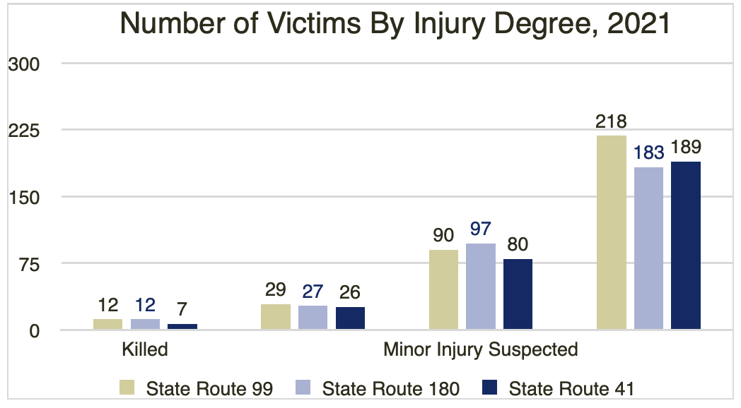 Number of Victims by Injury Degree, 2021; graph courtesy of author.[/caption]Did the Victim’s Air Bag Deploy During the Crash?Wearing a seat belt and riding in a vehicle with a properly-deploying airbag can save your life in a violent car crash. According to the National Highway Traffic Safety Administration (NHTSA), a frontal airbag is designed to open in a moderate to severe crash. Usually, this occurs during an impact with a fixed barrier at anywhere from eight miles per hour or higher. We were curious – how many car accidents on Fresno highways necessitated an airbag deployment? Using TIMS data, we were able to discover the number of crashes in which the collision victim’s airbag deployed. [caption id="attachment_4821874" align="aligncenter" width="600"]
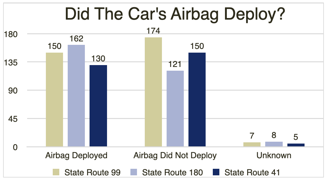 Did the Car's Airbag Deploy? Graph courtesy of author.

About Jake Sanborn
Jake graduated from the University of San Diego with a bachelor's degree in English and Political Science. When he's not putting together a legal article or analytical piece, you can find him enjoying a nice hike or camping in the Laguna Mountains with friends.